


Google brings nature to Maps. Since its launch 15 years ago, the application has changed its design several times, improving the services offered to users. In the latest update it will evolve again by introducing more colors that will make it easier to understand how the framed area looks if you decide to take a virtual tour or visit it in person.
The maps of the Californian giant are enriched with colors and details in order to distinguish the natural elements, from glaciers to deserts, from beaches to forests, for the more than 100 million square kilometers of land surface covered by Big G. And greater accuracy it also arrives in the city, in order to show sidewalks and pedestrian crossings to those who, also due to Covid-19, prefer to travel on foot.
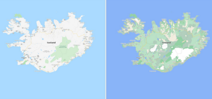
Google Maps has high-definition satellite imagery for over 98 percent of the world’s population. With a new color-mapping algorithmic technique, they are able to take this imagery and translate it into an even more comprehensive, vibrant map of an area at global scale.
“Exploring a place gives you a look at its natural features — Google writes on its blog – so you can easily distinguish tan, arid beaches and deserts from blue lakes, rivers, oceans and ravines. You can know at a glance how lush and green a place is with vegetation, and even see if there are snow caps on the peaks of mountaintops”.
With this update, Google Maps has one of the most comprehensive views of natural features on any major map app—with availability in all 220 countries and territories that Google Maps supports. That’s coverage for over 100M square kilometers of land, or 18 billion football fields.
This update is visible no matter what area you’re looking at—from the biggest metropolitan areas to small, rural towns.
How exactly does this color-mapping technique work? “First, we use computer vision to identify natural features from our satellite imagery, looking specifically at arid, icy, forested, and mountainous regions. We then analyze these features and assign them a range of colors on the HSV color model. For example, a densely covered forest can be classified as dark green, while an area of patchy shrubs could appear as a lighter shade of green”.
While seeing natural features can help you get a feel for an area, sometimes you need more information to get around safely and efficiently. Soon, you’ll be able to see highly detailed street information that shows the accurate shape and width of a road to scale. You can also see exactly where sidewalks, crosswalks, and pedestrian islands are located–crucial information if you have accessibility needs, like wheelchair or stroller requirements.
“These details are particularly helpful as more people are opting to walk or take other forms of solo transportation due to the pandemic – Google explains – We’ll start rolling out detailed street maps in London, New York, and San Francisco in the coming months, with plans to expand to more cities over time”.


