


Climate change is a complex phenomenon involving a wide range of interactions between extreme climate events and natural and anthropogenic components. Severe weather events affected large forest areas in the last decades, changing the ability to provide ecosystem services and in many cases altering forest stand structure. Climate change disturbances with anthropogenic contributions, make sustainable forest management increasingly difficult, in the mid- and long-term. In a changing environmental context, the need to use innovative technologies to support forest management decisions is growing.
Compared to the several technologies available to study ecosystem processes and dynamics, remote sensing is considered an essential tool less expansive, for providing thematic maps, analysis at wide local scale, and monitoring the evolution and change of forest vegetation cover. These informations can be used to assess the damage to the forest stands, plan post-disturbance restoration, enhance tourist-recreational function, and many other aspects related to forest ecosystem management.
What is remote sensing?
Remote sensing is an Earth observation remotely, based on spectral response of objects and surfaces of different nature. The basic principle is to capture at distance electromagnetic radiation reflected or emitted from objects observed.
Therefore, in remote sensing three elements are fundamental:
- an object or surface to be observed (in our case: forest vegetation);
- a platform to hold instrument;
- an optical sensor able to detect the quantity and quality of electromagnetic radiation reflected or emitted from objects or surface.
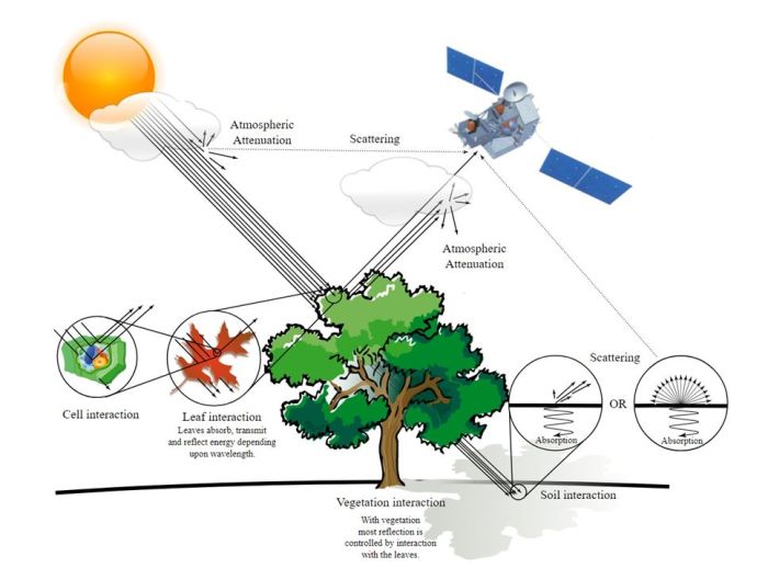
For example, even taking a picture of a tree with smartphone, is remote sensing. A tree is a target object, we are the platform, the camera is the sensor that detects electromagnetic radiation reflected from tree canopy.
Scientists use remote sensing to assess and study, composition and nature of objects on Earth’s surface remotely, using several platforms containing sensors such as satellites, drones, or aerial vehicles. The sensors can be passive (use solar radiation as an illumination source) and active “illuminate” the object through an artificial source emitting electromagnetic radiation at certain frequencies and recording the signal, as in the case of the environmental disturbances impact systems.
How vegetation forest is monitored?
Passive sensors measure the radiation sunlight emitted or reflected by vegetation in the different portions of the electromagnetic spectrum called bands, returning for each band an image with different levels of reflectance, i.e. reflected energy. The electromagnetic spectrum portion that ranges visible region (blue, green, red) to the near-infrared region, is sensitive to the vegetation.
Specifically, red and near-infrared bands provide insights of vegetation conditions. In the case of healthy vegetation, i.e. photosynthetically active, plant pigments absorb radiation incident in the red, while near-infrared strongly reflects by leaf spongy mesophyll. While, in unhealthy vegetation, radiation absorbs less in the red band due to reduced chlorophyll activity.
These vegetation response variabilities in incident radiation can be estimated through a combination of spectral reflectance between red and near-infrared bands of one of vegetation index: Normalized Differenced Vegetation Index (NDVI).
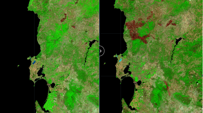
Numerous satellite constellations acquire data available on commercial sources or open-source tools. Remote sensing platforms such as European Copernicus (ESA – European Space Agency) and United States National Aeronautics and Space Administration (NASA) – Landsat e Terra/Aqua are well-known. These data may be used to monitor forest resources at local, regional, national/continental scales, due to their spatial resolution (pixel size of an image representing the size of the surface area on the ground).
Nowadays, Landsat and Sentinel are widely usedto assess forest vegetation change cover, detecting forest logging, wildfires, snow, and wind crashes, and more generally the healthy forests condition and environmental disturbances impact.
In addition to the satellite data, recent technologies opened new frontiers using 3D information offered by active sensors such as LIDAR (measure distances through pulsed laser) or Unmanned Aerial Vehicle (UAV) (e.g. drones), providing high-precision data.
The use of satellite data with innovative technologies integration, provide new opportunities in the land governance and applications site-specific field. This novel approach can play an important role in promoting efficiently sustainable management of forest resources within a climate change scenario.


