


Forests are essential for our environment, society and economy. Beyond mitigating climate change and natural disasters, forests are also crucial ecosystems for biological diversity. However, these ecosystems serve other valuable functions, including soil conservation, water cycle regulation, carbon storage, providing resources and habitat. The Global Forest Resources Assessment Report (FAO, 2020) estimates that the world forests cover 4.06 billion hectares, showing that more than half (54 percent) are located within five major countries: Russia, Brazil, Canada, the United States and China. According to the FAO report, deforestation has resulted in the loss of 420 million hectares of forests since 1990.
However, the report shows a decreasing forest loss, between 2015 and 2020. Likewise, FAO report also highlights that European forests cover about 140 million hectares, equal to 36 percent of total land area. In this regard, the EU Commission has introduced the new Forest Strategy 2030, which aims to protect, restore and expand forest areas, reducing climate change impacts and biodiversity loss. Furthermore, it aims to promote valuable forest ecosystems, such as primary and old-growth forests, with a focus on increasing sustainable development in rural areas. These issues are driving government, as well as non- other organizations, toward adopting new tools for simplified and improved natural resource monitoring, with special focus on forest ecosystems. Here, use of innovative tools is fundamental to ensure forest conservation and develop long-term sustainable strategies. In recent years, several monitoring tools, such as remote sensing and geographic information systems (GIS) have been developed.
The new technologies could be a powerful resource for researchers, government policy makers, and organizations who want to enhance their understanding about ecological dynamics, biodiversity loss, forests, and sustainable development. Paper objective was to explore two free tools proposed by both governments and international organisations, aiming to improve knowledge about their strategic role, functionalities and applications in forest monitoring.
SEPAL and Global Forest Watch
A recent tool for monitoring forests and land-use change at a global scale is Open Foris. It is an open-source software that assists in data collection, analysis and reporting. One of its latest components is the System for Earth Observation Data Access, Processing and Analysis of Land Monitoring (SEPAL). SEPAL is an easy-to-use cloud computing platform for accessing and analysing geospatial data. It enables users to quickly process large datasets directly on their own computers or mobile devices. Users can thus generate freely customised analyses by using satellite images to conduct time and space investigations. SEPAL integrates spatial data and computing power from Google Earth Engine and Amazon Web Services, using other popular applications including R, ORFEO, GDAL, Python and Jupiter Notebooks. Originally, it was introduced to monitor forest carbon stocks and forest changes under the Reducing Emissions from Deforestation and Forest Degradation (REDD+) project. The REDD+ project aimed to reduce emissions due to deforestation and forest degradation. As part of this programme, SEPAL provided a rich set of tools used to monitor and assess forest resources, carbon stocks and land-use changes. As a result, SEPAL considerably improved land monitoring and facilitated management and analysis of big data.
Using advanced technologies and processes, users can conduct guided analyses, reducing both potential errors and time. This software includes several packages useful in forest monitoring, such as real time analysis about forest disturbances, forest fires or forest change detection.

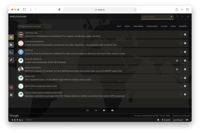
SEPAL is accessible through a web portal (https://sepal.io). On the web portal, functionalities are divided in four areas: process, file, terminal and applications. The Process area enables users to select images for their analysis using criteria such as area, sensor (Landsat or Sentinel), and time of interest. After browsing, users can then download their best images into a storage area in order to produce a mosaic or other output. The Files section allows users to view previously saved files. The Terminal area allows users to start a machine in the AWS cloud. Before executing the task, users must select one of the available hardware configurations. The Apps panel contains several applications for analysing data. When selecting an option, the code is automatically launched by SEPAL on the user machine (Fig. 2).

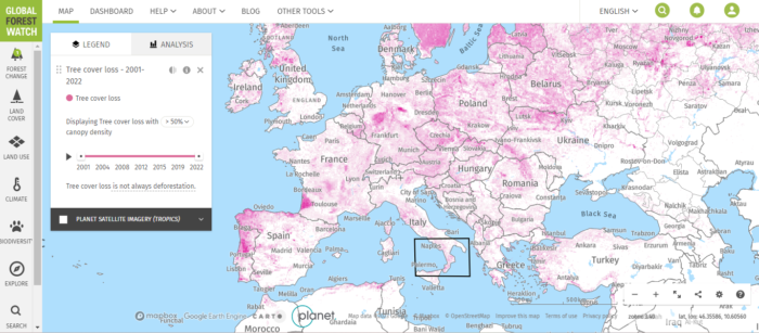
Although SEPAL provides functionality useful to manage and view data on the web interface. Other actions such as editing or sharing analysis are not possible. SEPAL is not the only tool for monitoring and assessing forest resources. For instance, Global Forest Watch (GFW), launched by the World Resources Institute, represents another relevant tool. GFW is a network that aims to promote transparency in forest management decisions by promoting public access to information. The Global Forest Monitoring (GFMN) was established in 1997 as part of the Forest Frontiers initiative. Its aim was to supply timely data about forest cover change and deforestation rates. GFW provides open access to real-time satellite images and global forest data. It allows people to explore, compare and analyze these data in order to detect and deforestation trends or other potential hotspots (Fig. 3).

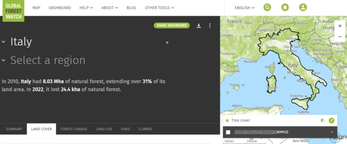
GFW also offers other layers such as protected areas, air quality index or global fire index. The interactive maps contribute to better understanding deforestation drivers and help to make informed decisions. The first version focused on four countries: Cameroon, Canada, Gabon, and Indonesia. However, GFW has evolved and today includes information about more than 90 countries. Currently, it provides real-time alerts on forest loss, accurate forest cover maps and sophisticated analytical tools. Additional user-friendly applications, such as the Global Forest Explorer, are also available for exploring and comparing global forest trends. In order to access GFW, visit the Web site (https://globalforestwatch.org/map) and register a free account. Once the account is created, GFW’s dashboard is accessible for visualising global and country-level maps. Many inputs are available from the dashboard, including deforestation (Fig. 4), forest degradation and land-use change maps, as well as data on forest cover, protected area boundaries and carbon emissions.

Forest area loss and gain maps are displayed by default. Access to alert data, for example GLAD or fire alarms, requires going to the “FOREST CHANGE” menu. Again, like SEPAL, it is free and offers several options, such as creating and customising maps, receiving alerts and downloading data for specific study areas. Specifically, GFW is a valuable tool to understand forest change, detect deforestation and prevent illegal logging. However, it can also be used to assess policies and climate change impacts. Both GFW and SEPAL are complementary tools with their own features. Indeed, they can be used to provide a more comprehensive view regarding the global forest status. As a complement, the Forest Atlas, produced by the EU’s Joint Research Centre, is focuses on European forest monitoring. The Forest Atlas allows EU policy makers to assess policy effectiveness and monitor their progress towards sustainable goals. Through its information, Forest Atlas is a valuable data source for communities, operators and forest owners. It is also a key resource to ensure sustainable forest management in Europe, looking forward to the next generations.
Opportunities, challenges and future perspectives
SEPAL and Global Forest Watch are both emerging as effective forest monitoring tools, providing user-friendly approaches for experts and non-experts equally. One major advantage is that these are open source tools, making them available to a large user group including governments, non-governmental organisations (NGOs) and local communities. Providing timely data on forest cover, deforestation, biodiversity and other indicators, they can support governments and stakeholder efforts, ensuring sustainable forest management. Also, they can be used as educational tools to increase knowledge and understanding about forests and their value. Additionally, they contribute to international cooperation towards more effective forest ecosystem monitoring and management. However, it is important to recognize some limitations, such as data gaps for certain countries and satellite image inaccuracies. Consequently, they cannot be used to provide reliable information for some areas. Addressing this issue is thus a priority and calls for further research, study and investment to develop novel approaches in order to increase their effectiveness and usefulness. Specifically, improving satellite data availability as well as the investments in new technologies (i.e. Drones and other sensors) would be helpful. Overcoming such challenges will enable us to collectively work for the conservation and protection of our invaluable forest ecosystems.


